
Description
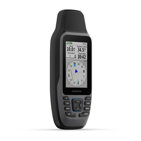
Stay on course, and track more adventures with these rugged, floating handhelds. GPSMAP® 79 marine handheld series designed to equip mariners with a suite of essential, easy-to-use onboard navigation tools from the palm of their hand. Building on the legacy of the GPSMAP 78 series, the GPSMAP 79 series introduces an all-new design with modern display features to enhance navigation and peace of mind for boaters as they explore open waters. Packed securely in a rugged, floating design, the GPSMAP 79 series is purpose-built to suit a variety of on-water lifestyles.
- Water-Resistant, It Floats, And It’s Fogproof, So It Belongs On The Water
- Can Remember Up To 10,000 Waypoints And More
- Nice To Have Reliable Positioning When You’re Out On The Water
- Built-In Compass Will Point You In The Right Direction
- Get The Best Of Garmin And Navionics ® Data With BlueChart ® G3 Coastal Charts
- Stay Out Longer With Up To 19 Hour Of Battery Life In GPS Mode
- Limited 1 Year Warranty
Specifications:
-
High-sensitivity receiver: Yes
-
Dimension: 2.67″ x 6.85″ x 1.67″ (6.77 x 17.40 x 4.23 cm)
-
Display Size: 1.5″W x 2.5″H (3.8 x 6.3 cm); 3″ diag (7.6 cm)
-
Display resolution: 240 x 400 pixels
-
Display Type: transflective, 65K color TFT
-
Weight: 9.95 oz (282g) with batteries
-
Battery type: 2 AA batteries (not included); NiMH or Lithium recommended
-
Battery life: up to 19 hours
-
Waterproof: IPX7
-
MIL-STD-810: yes (thermal, shock, water); bare unit only
-
Interface: high speed microUSB and NMEA 0183 compatible
-
Memory/History: 8 GB (user space varies based on included mapping on sc version)
-
Preloaded maps: BlueChart g3 coastal charts
-
Ability to add maps: Yes
-
Basemap: Yes
-
Automatic routing (turn by turn routing on roads) for outdoor activities: Yes (with optional mapping for detailed roads)
-
Map segments: 15000
-
Includes detailed hydrographic features (coastlines, lake/river shorelines, wetlands and perennial and seasonal streams): Yes (downloadable from Garmin Express™)
-
Includes searchable points of interests (parks, campgrounds, scenic lookouts and picnic sites): Yes (downloadable from Garmin Express™)
-
Displays national, state and local parks, forests, and wilderness areas: Yes (downloadable from Garmin Express™)
-
External memory storage: yes (32 GB max microSD™ card, not included)
-
Waypoints/favorites/locations: 10000
-
Tracks: 250
-
Navigation Track Log: 20,000 points, 250 saved gpx tracks, 300 saved fit activities
-
Navigation Routes: 250, 250 points per route; 50 points auto routing
-
Rinex logging: Yes
-
GPS: Yes
-
GLONASS: Yes
-
Galileo: Yes
-
QZSS: Yes
-
SBAS: Yes
-
Compass: Yes (tilt-compensated 3-axis)
-
GPS compass (while moving): Yes
-
Point-to-point navigation: Yes
-
Area calculation: Yes
-
Hunt/fish calendar: Yes
-
Geocaching-friendly: Yes (Paperless)
-
Custom maps compatible: Yes
-
Picture viewer: Yes
Includes:

Reviews
There are no reviews yet.