
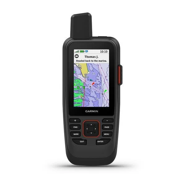
Description
Cast off confidently with the GPSMAP 86sci handheld. Whether you”™re out for a day of fishing, sailing or cruising, you”™ll gain peace of mind that comes from having a backup navigator with satellite communication and interactive SOS. This premium handheld floats and has a sunlight-readable 3″ color display. Plus, wireless connectivity makes it a virtual extension of your onboard marine system, giving you added awareness and convenience.
- Water-Resistant, And It Floats, So It’s As At Home On The Water As You
- See All Your Marine System Info At A Glance With Boat Data Streaming
- Cruise With Peace Of Mind, InReach Interactive SOS Is There If You Need It
- Send And Receive Text Messages From Anywhere
- Get The Best Of Garmin And Navionics® Data With Preloaded BlueChart G3 Coastal Charts
- Stay Out Longer With Up To 35 Hour Of Battery Life In 10-Minute Tracking Mode
- Sync GPSMAP 86sci With Garmin Explore For Cloud Management Of Your Favorite Waypoints, Tracks And Routes
- GPSMAP 86sci Helps You Keep Gear To A Minimum With A Built-In LED Flashlight That Can Be Used As A Beacon To Signal For Help
- GPSMAP 86sci Offers Wi-Fi® Connectivity, ANT+® Technology And BLUETOOTH® Wireless Technology For Easy Wireless Updates And Connections
- Limited 1 Year Warranty
Specifications:
-
Physical dimensions: WxHxD: 2.75″ x 7″ x 1.7″ (7 x 17.8 x 4.4 cm)
-
Display size: 1.5″W x 2.5″H (3.8 x 6.3 cm); 3″ diag (7.6 cm)
-
Display resolution: 240 x 400 pixels
-
Display type: transflective, 65K color TFT
-
Weight: 9.59 oz (272 g)
-
Battery: rechargeable internal lithium ion
-
Battery life: Up to 35 hours in 10-minute tracking mode; up to 200 hours (expedition mode)
-
Water rating: IPX7
-
Memory/History: 16 GB
-
High-sensitivity receiver: Yes
-
Interface: high-speed USB and NMEA 0183 compatible
-
Preloaded maps: Yes
-
Ability to add maps: Yes
-
US BlueChart g3 Charts: Yes
-
Memory Storage and Power Capacity: microSD™ card (not included)
-
Waypoints/favorites/locations: 10000
-
Routes: 250
-
Track log: 20,000 points, 250 saved gpx tracks, 300 saved fit activities
-
Barometric altimeter: Yes
-
Compass: Yes (tilt-compensated 3-axis)
-
Area calculation: Yes
-
Automatic routing (turn by turn routing on roads): Yes (with optional mapping for detailed roads)
-
Geocaching-friendly: Yes (Paperless)
-
Custom maps compatible: Yes
-
Hunt/fish calendar: Yes
-
Sun and moon information: Yes
-
Picture viewer: Yes
-
Garmin Connect™ compatible (online community where you analyze, categorize and share data)
Includes:
Reviews
There are no reviews yet.